zondag 17 mei 2015

Zuilen 5

SUMMARY & EXPLANATION PILLARS
What did the classical authors know really about the straits of Gibraltar, which they called the columns of Heracles.


CALPE
Calpe is the traditional name for the Rock of Gibraltar. Is it an original Greek name (Kalpe), or is it a hash of a Phoenician name? If it is a Greek name, it means something like rounded hill or mountain with a round top. Such storage is also present in Greece. If it is a distortion of a Phoenician name, we arrive at Qal = voice and Pe = mouth. Possibly Py = permission. Combined it has something to do with a voice that gives permission? Permission for what? We know that the Greeks many centuries needed the permission of the Phoenicians and Carthaginians to sail beyond the Pillars of Hercules. If then on closer inspection the Rock of Gibraltar did not show on such a rounded shape to have, I prefer the Phoenician solution. The fact remains that it perhaps could have an entirely different meaning.

ABILA, ABILYX, (H)ABENNA, APINI, ABINNA
The cape at Ceuta gets several names in antiquity, but they have all the same structure. This swith between the N and L occurs more often in other words. It could well be a distortion of the Phoenician name ‘B N = stone.

THE ISLANDS?
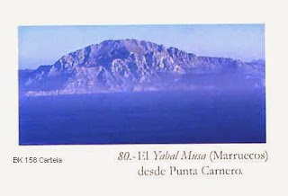
Several classical authors mention the islands near the capes. Were they the real small islands Perejil and Isla Cabrita? I suspect that the islands were in fact the capes itself, because from a distance they look like islands (Strabo!). It concerns Gibraltar and Mount Hacko.

PILLARS OF MELQART
These are to be found at Gadir at the isle Sancti Petri in front of the temple of Melqart. And that is exactly what the Iberians and Libyans say about it. The mountains at the beginning of the Straits the Phoenicians named simply ‘B N (stone) and Q L P ‘ (permission to continue).

PILLARS OF HERACLES/HERCULES.
The Greeks were for a long time not familiar with the Atlantic world, heard something about Pillars and concluded that it must concern the landmarks on the capes at the beginning of the Straits, Of course they used their own name for the god: HERACLES.  The Roman used the name HERCULES.


Zuilen 4

PILLARS IV (by the later classical writers)
What did the classical authors know really about the straits of Gibraltar, which they called the columns of Heracles.

Strabo 1st century BC / 1st century AD
He quotes for a part Euctemon. He writes in Geography III, 5,3:
Close to the Pillars there are two isles, one of which they call Hera’s Island; moreover there are some who call these Isles the Pillars.”
Geography III, 5,5:“… Again, some have supposed that Calpe and Abilyx are the Pillars, Abilyx being that mountain in Libya opposite Calpe which is situated, according to Eratosthenes in Metagonium, country of a nomadic tribe; one of which they call Hera’s Island, are the Pillars. Artemidorus speaks of Hera’s Island and her temple, and he says there is a second isle, yet he does not speak of Mount Abilyx or of a Metagonian tribe.”
Furthermore: the region outside the Pillars is fertile. Passing the strait delivers some difficulty. Strabo notices the sea-oak: That creature is present inside and outside the pillars. It is covered with ahorns. He mentions an oracle to the Tyrians ordering them to send a colony to the Pillars. The thought that “those Pillars which are in the temple of Heracles at Gades as the Pillars of Heracles is less reasonable”. But this is exactly what happened! I will explain it later. He talks also about Calpe as follows: “I mean Calpe, which, although its circumference is not great, rises to so great height and is so steep that from a distance it looks like an island.”
Strabo tells us finally of a Phoenician ship off the west coast of Spain which, seeing that it was being followed by a Roman vessel, deliberately went aground on underwater rocks, causing the Italian galley to do likewise. When the Phoenician captain returned home he was awarded the price of the boat and the cargo, he had sacrified, as compensation.

Pomponius Mela 1st century AD
I 27: …. This is followed by a very high mountain, of the one that Spain can ascend on the opposite side, opposite is: This is Abila, the other Kalpe, both together Pillars of Hercules.
He describes also the separation of the mountains and the entry of the ocean.

Ptolemeus 2nd century AD
In his Geography (IV 3,4+3,7)  he distinguishes Ad Septem Fratres (coordinates: L 7-40, W 35-50) from the Pillar of Abila (coordinates L 7-50, W 35-40) locating the latter to the southeast of Ceuta. He mentions also the place Exilissa.

Philostratus 2nd century AD
Around 170 AD he writes in the Life of Apollonius of Tyana (V,1):
the extremity of Libya, which bears the name Abinna.”

Itinerarium Antonini 3rd century AD
He makes a distinction between the town Ad Septem Fratres and the Pillar (Monte del Hacko) situated to the northeast of the town.

Avienus 4th century AD
In the verses 345-346 in Ora Maritima he talks about the town Abila.

Eustathius 4th century AD
Paraphrase of Dionysius Periegetes:
as for the Libyan (Pillar) it is called Abenna by Barbarians, but Huntress in Greek.”

Orosius 5th century AD
Probably in the year 414 AD he writes in Historiae adversus Paganos (T 2,94):

fretum Gaditanum quod inter Habennae et Calpis duo contraria sibi promuntoria coartatur’’ He describes here the straits of Gadir, which narrow between the two opposite promontories of Abenna and Calpe.

Zuilen 3

PILLARS III (The Romans made an end to the blockade).
What did the classical authors know really about the straits of Gibraltar, which they called the columns of Heracles?

Polybius 2nd century BC
II, 1: “….he crossed the Pillars of Herakles and began to seize power over Spain for the Carthaginians.” (Hamilcar in 238/7 BC).
III, 37: Polybius divides the civilized world into three parts, the pillars of Hercules are an important calibration point.
III, 39: He gives the distances between the Pillars and Carthago-nova (3000 stadia) and the Pillars and the Pyrenaeans (8000 stadia).
X, 7: “Mago kept himself on this side of the Pillars of Herakles in the region of Konians.”
(Scipio in his first appearance in Spain).
X, 40: “the largest and most beautiful areas of North Africa from the altars of Filainos to the pillars of Hercules brought under the control of his homeland.” (about Scipio).
XVI, 29: “…because the street at the pillars of Hercules is much broader than that at the Hellespont. The former street is 60 furlongs wide and at Abydos two ....
.... But the straits at the Pillars of Hercules is only rarely and then used by few people because there is no regular contact between the peoples who live, respectively, to the point of Europe and Africa and because the Outer Ocean is unknown to them.”
Polybius equates the straits of Heracles and Abydos. The Romans are going to be better informed about the region of the straits.

Plinius 1st century BC
In his Natural History (III,4 + V,18) he speaks of the town Lissa.
“….where the gorge is the narrowest, choking high mountains on both sides of the aisle, the Abila in Africa, in Europe Calpe, the landmarks of the labours of Hercules. Therefore, the indigenous people call this the pillars of this god and they believe that this mountain had first pierced and only then the seas were admitted that were excluded before, and this is according to them that changed the sight of nature radically.”
This phenomenon really happened once, but that was maybe a 100.000 years ago!!!!


Diodorus 1st century BC
IV, 18,1: “… and after Heracles had visited a large part of Libya he arrived at the ocean near Gadeira, where he set up pillars on each of the continents.”
IV, 18,4: “But since we have mentioned the pillars of Heracles, we deem it to be appropriate to set forth the facts concerning them. When Heracles arrived at the farthest points of the continents of Libya and Europa which lie upon the ocean, he decided to set up these pillars to commemorate his campaign. And since he wished to leave upon the ocean a monument which would be in everlasting remembrance ….”

Diodorus has more specific information after this legend concerning the pillars. He repeats the already available information about the name of the capes: Calpe and Abilyx and the isles (Hera island). It becomes interesting, when he mentions the possibility (according to Pindarus), that there are also pillars outside the strait. He calls them Planctae and Symplegades as the gates of Gades. He shares the information of Poseidonius, who is asking himself, if the bronze pillars of eight cubits in the temple of Heracles at Gades are the real pillars! This is what the Iberians and Libyans are saying! Diodorus also refers to the habit to set op landmarks (Pelorus, Philaeni, Corinthe).

Zuilen 2

PILLARS II (end of the monopoly in sight).

The maritime monopoly of the Phoenicians lasting some 500 years, if the traditional foundations of Cadiz, Lixus and Utica are true, is slowly coming to an end. So far the Phoenician triangle of Carthage-Sicily-Sardinia was practically impregnable and closed the Straits of Gibraltar to Greek competition. But the Phoceans and especially Masalia (Marseille) tried to penetrate more and more from the north. They went along to east-coast of Spain to the south (Ampurias, Alonae, Artemision, Hemeroskopeion, Mainake?). And a daring Masilian captain went even further.

Ps.Scylax 4th century BC
Some Greek sailor managed to break through the blockade and researched the Western Europe coasts. He provides more accurate informationabout the pillars, but not very much.
The low Pillar is in Libya and the high one lies in Europe. They are separated from each other by a day-long voyage.” He mentions also the place Abini or Apini.

By now, the Phoenicians, Heracles, Melqart, and indirectly the founding of Gadir, Lixus and Utica, were mixed up in one and the same block of Greek legends.

Eratosthenes 3rd century BC
Abilyx is a mountain that lies in Metagonium, country of a nomadic tribe. According to Strabo he also mentions the places Apini and Abiluka. The statements of Eratosthenes are done on information from Ephorus.

Artemidorus 2nd century BC

He talks about two islands near the pillars. He speaks of Hera’s Island and her temple, and he says there is a second isle. These islands could be Perejil near Ceuta and Isla Cabrita near Algeciras.

Zuilen 1


PILLARS I (the monopoly).

What did the classical authors know really about the straits of Gibraltar, which they called the columns of Heracles or FRETUM GADITANUM.  Whatever the case, driven by the desire to acquire new and more remunerative sources of raw materials and to sell their products to markets other than in the homeland, the Phoenicians covered enormous distances, being the first to trace routes to the western Mediterranean and beyond the Pillars of Heracles/Hercules towards the Atlantic coasts of Africa and Europe. The Phoenicians had already founded Gadir in the ocean. To the north they reached Santa Olaia in Northern Portugal and to the south they were present in Mogador in southern Morocco. Probably Hanno had made already his sea-journey along the west-coast of Mauretania or even much further. Himilco could have been already on his way to Western Europe. The Carthaginians had assembled a lot of information of this new world, but they kept strange eyes far away and blocked the straits. The Atlantic trade became a monopoly which the Carthaginians and Gaditans were careful to protect. Their pilots jealously guarded the secrets of the winds, currents and anchorages, while at the same time spreading rumours about the extreme dangers involved in navigation along these routes so as to discourage the opposition. Those who were not so easily deterred, and who actually dared to follow in the wake of the Carthaginian or Gaditan ships, were taken a great risk, since their masters did not hesitate to kill, if necessary, in order to keep curious eyes at a safe distance. Nevertheless some information began to reach the Greek world.
{texts from Aldo Massa, The Phoenicians, 1977, p.77; P.Bartaloni, I Fenici, 1988, p.72}.

Euctemon 5th century BC
He talks about two islands near the pillars and not so much about the straits. The islands seem to be more important. This could be attached to the story that foreign ships had to wait by these islands in order to get the approval of going on. The Phoenician sailors went ashore in Gorham’s cave, a sanctuary on the Mount Gibraltar in order to get a save passage through the Straits.

Apart from the much quoted Homer, whose heroes probably entered Libya, another important reference is Herodotus, offering a picturesque account of Carthaginian merchants with their vessels loaded with a bounty of assorted goods, and telling how they sailed out past the pillars of Heracles to reach the inhabitans of the Atlantic coastlands and nearby mountains.
{M’hamed Fantar, I Fenici, 1988, p.168}

Herodotus 5th century BC
He provides not much information, despite his efforts to say something. It is a combination of legends (Geryonès, Atlanteans) en real information (Kynesians).
I, 202: “…because the entire sea, which is navigated by the Greeks and the so-called Atlantic sea beyond the Pillars and the Red Sea are actually one sea.”
II, 33: “….The Celts are living beyond the Pillars of Heracles, and border on the Kynesians which from all those living in Europe live furthest to the west.”
IV, 8: “….Geryonès however lived outside of Pontos and did so on the island named by the Greeks Erytheia at Gadeira beyond the Pillars of Hercules to the Okeanos.”
IV,42: “…..so they fetched a compass after two years in the third year of the pillars of Heracles and again came into Egypt.”-> The Phoenician sailors of Necho!
IV, 185: “To which Atlanteans I can enumerate the names of the people who live in the sand strip, but no further. In any case, the strip passes to the columns of Heracles and even beyond.”